Royal Livingstone Hotel
 

Victoria Falls - Destination Information

History


David Livingstone

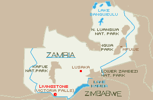
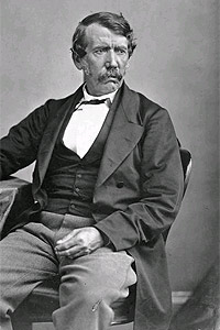
Born in Scotland, David Livingstone arrived in Africa in 1840 at the age of 27 as a missionary and physician. He spent most of the remainder of his life on the continent, his exploits making him the most famous explorer of the century. An encounter with a lion in 1843 cost Livingstone the use of his left arm. Livingstone continued his exploration of the African interior despite the loss of has arm,  he was particularly interested in the Zambezi River area in 1852-1856.

It was during this expedition that he became the first European to witness the magnificence of Victoria Falls.

In 1866, Livingstone set out at the head of an expedition charged with the task of finding the headwaters of the Nile River. His lack of contact with the outside world over a period of four years raised concerns for his welfare and prompted the New York Herald to send Henry Stanley to find Livingstone.

Stanley achieved his goal on November 10, 1871 approaching the explorer in an African village with the immortal words "Dr. Livingstone I presume" Years in the wilderness took their toll however, and David Livingstone died in Africa in April 1873 at age sixty.

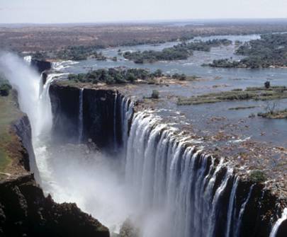
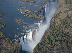
In early November 1855, Livingstone traveled down the Zambezi River to see for himself the area the natives called "smoke that thunders." Approaching the spot in canoes, the party could see the columns of spray and hear the thunderous roar of water miles away from the falls:

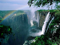
"After twenty minutes' sail from Kalai we came in sight, for the first time, of the columns of vapor appropriately called 'smoke,' rising at a distance of five or six miles, exactly as when large tracts of grass are burned in Africa. Five columns now arose, and, bending in the direction of the wind, they seemed placed against a low ridge covered with trees; the tops of the columns at this distance appeared to mingle with the clouds. They were white below, and higher up became dark, so as to simulate smoke very closely. The whole scene was extremely beautiful; the banks and islands dotted over the river are adorned with sylvan vegetation of great variety of color and form…no one can imagine the beauty of the view from any thing witnessed in England. European eyes had never seen it before; but angels in their flight must have gazed upon scenes so lovely. The only want felt is that of mountains in the background. The falls are bounded on three sides by ridges 300 or 400 feet in height, which are covered with forest, with the red soil appearing among the trees.

When about half a mile from the falls, I left the canoe by which we had come down thus far, and embarked in a lighter one, with men well acquainted with the rapids, who, by passing down the centre of the stream in the eddies and still places caused by many jutting rocks, brought me to an island situated in the middle of the river, and on the edge of the lip over which the water rolls. In coming hither there was danger of being swept down by the streams that rushed along on each side of the island; but the river was now low, and we sailed where it is totally impossible to go when the water is high. But, though we had reached the island, and were within a few yards of the spot, a view from which would solve the whole problem, I believe that no one could perceive where the vast body of water went; it seemed to lose itself in the earth, the opposite lip of the fissure into which it disappeared being only 80 feet distant. At least I did not comprehend it until, creeping with awe to the verge, I peered down into a large rent which had been made from bank to bank of the broad Zambezi, and saw that a stream of a thousand yards broad leaped down a hundred feet, and then became suddenly compressed into a space of fifteen or twenty yards.

The entire falls are simply a crack made in a hard basaltic rock from the right to the left bank of the Zambezi, and then prolonged from the left bank away through thirty or forty miles of hills. If one imagines the Thames filled with low, tree-covered hills immediately beyond the tunnel, extending as far as Gravesend, the bed of black basaltic rock instead of London mud, and a fissure made therein from one end of the tunnel to the other down through the keystones of the arch, and prolonged from the left end of the tunnel through thirty miles of hills, the pathway being 100 feet down from the bed of the river instead of what it is, with the lips of the fissure from 80 to 100 feet apart, then fancy the Thames leaping bodily into the gulf, and forced there to change its direction, and flow from the right to the left bank, and then rush boiling and roaring through the hills, he may have some idea of what takes place at this, the most wonderful sight I had witnessed in Africa.

In looking down into the fissure on the right of the island, one sees nothing but a dense white cloud, which, at the time we visited the spot, bad two bright rainbows on it. From this cloud rushed up a great jet of vapor exactly like steam, and it mounted 200 or 300 feet high; there condensing, it changed its hue to that of dark smoke, and came back in a constant shower, which soon wetted us to the skin…

On the left of the island we see the water at the bottom, a white rolling mass moving away to the prolongation of the fissure, which branches off near the left bank of the river… The walls of this gigantic crack are perpendicular, and composed of one homogeneous mass of rock. The edge of that side over which the water falls is worn off two or three feet, and pieces have fallen away, so as to give it some- what of a serrated appearance. That over which the water does not fall is quite straight, except at the left corner, where a rent appears, and a piece seems inclined to fall off Upon the whole, it is nearly in the state in which it was left at the period of its formation…On the left side of the island we have a good view of the mass of water which causes one of the columns of vapor to ascend, as it leaps quite clear of the rock, and forms a thick unbroken fleece all the way to the bottom. Its whiteness gave the idea of snow, a sight I had not seen for many a day. As it broke into (if I may use the term) pieces of water, all rushing on in the same direction, each gave off several rays of foam, exactly as bits of steel, when burned in oxygen gas, give off rays of sparks. The snow-white sheet seemed like myriads of small comets rushing on in one direction, each of which left behind its nucleus rays of foam."


Best Time To Visit The Victoria Falls


The Victoria Falls

Visiting the falls depends on whether you want to view the Falls at its most impressive or at its lowest flow. For example if you want to view the falls up close you will want to be there at its lowest flow.As there are numerous factors that come into play it is very difficult to predict the best time for doing both.The Falls is in its highest flow around May-June time frame. You could then expect the falls to span the entire 1.7km width of the Zambezi River as it plunges over its 108m wall. Unfortunately, during this time most of the viewpoints are too wet to photograph effectively (careful not to destroy your equipment by exposing it in the rain) and Raincoats are a must. This would be the perfect time to view the Falls from the air.

The Falls is in its lowest flow around October-December time frame. During these conditions the falls will brake up into subgroups comprising of seven smaller water “strands”, with much of the underlying bedrock exposed along the wall. Lacking its thunderous impact due to some degree of water diversion for hydroelectricity, but plenty of other activities become possible.

Among these activities are swimming at the “Devil's Swimming Pool” that lets you swim right at the edge of the Falls!


And other water activities in the Zambezi River below the falls becomes possible. Mist obscuring your viewpoints won't be a problem.

During July through September is perhaps the most popular time frame to visit the Falls (good views and best weather). Gradually in transition from a flooded state to a low flow state with an acceptable volume of water and fewer problems with mist.This would probably be the best time to go in terms of getting the best of both worlds taking in the impressive visual impact of the Falls and partake in the most activities.


victoria falls hotels   view of the falls


Around January through March/April is the wet season. The area is Warm and extremely humid and thundershowers are more likely. During this period the Falls are in transition, going from a low flow state to a high flow state. Thus, you're likely to have satisfying views of the falls without mist being as much of a problem as during full flood. Even though it is typically raining this time of year, the flow of the River depends on the drainage systems further upstream where water drains into the Zambezi River from Western Zambia and Angola.


Size and flow rate of Victoria Falls

Parameters
Victoria Falls
Height in meters and feet: 108m 360 ft
Width in meters and feet: 1,708 m 5,604 ft
Flow rate units (vol/s): m³/s cu ft/s
Mean annual flow rate: 1,088 38,430
Mean monthly flow— max: 3,000 105,944
— min: 300 10,594
— 10yr max: 6,000 211,888
Highest recorded flow: 12,800 452,00


The Victoria Falls


Described by the Kololo tribe living in the area in the 1800’s as ‘Mosi-oa-Tunya’ - Victoria Falls are a spectacular sight on the Zambezi River, bordering Zambia and Zimbabwe.

Columns of spray can be seen from far away as 546 million cubic meters of water per minute plummet over the edge (at the height of the flood season) over a width of nearly two kilometers into a deep gorge over 100 meters below. The wide basalt cliff, over which the falls thunder, transforms the Zambezi from a wide placid river to a ferocious torrent cutting through a series of dramatic gorges.

Facing the Falls is another sheer wall of basalt, rising to the same height and capped by mist-soaked rain forest. A path along the edge of the forest provides the visitor who is prepared to brave the tremendous spray with an unparalleled series of views of the Falls.

One special vantage point is across the Knife edge bridge, where visitors can have the finest view of the Eastern Cataract and the Main Falls as well as the Boiling Pot where the river turns and heads down the Batoka Gorge. Other vantage points include the Falls bridge and the Lookout Tree which commands a panoramic view across the Main Falls.

Today, Victoria Falls remains as evocative a destination as it did to the hunters, surveyors, explorers and missionaries of the 19th Century.

Today, the wanderlust is the same, the pursuits are slightly different..

Zambia Zimbabwe Map


Victoria Falls Today


Zambia's tourist capital the historic town of Livingstone has become one of the best traveling destinations in Africa. Most visitors come for Victoria Falls, but the town has attractions of its own - a genteel colonial history combined with a very African ambience. Livingstone is only a short distance from the falls and is not far from the national parks.

The large but tidy Livingstone Museum Mosi-oa-Tunya Rd; is the oldest museum in Zambia. Highlights are the Tonga ritual artifacts, life-size model African village, a collection of David Livingstone memorabilia and display of maps dating back to 1690.
Mukuni is a local village of about 7000 Leya people. Tourists can visit the village to find out more about their traditional way of life, while the admission fee helps fund community projects.

The village is 18km (11mi) southwest of Livingstone and only accessible by taxi.


How the Falls were Created


It is thought that earth movement in an earlier geological period diverted the southeasterly flowing upper Zambezi to a general easterly direction and so initiated the development of a waterfall in an area occupied by a massive bed of basalt which is about 305 m thick.

The basalt, through which the Zambezi runs for 209 km in the Livingstone area is characterized by very marked joints or cracks, which may have developed as the molten lava cooled. One dominant series of joints running in an east-west direction is associated with zones of soft material within the basalt.

Since the Zambezi is flowing due south in the Livingstone area, these softer materials are very easily eroded to form the great east-west gorges. Upstream retreat of the Falls is due to a second major series of joints running north-south. Gradual erosion of small joints that run north-south caused the river to be concentrated into a narrow fissure and the broad fall line was abandoned. Once this happened, it was only a matter of time before the narrow gorges cut back into another transverse fracture zone of soft material. This gouging out of the soft zone again established a broad fall. This process has been repeated over many years and the zigzag gorges represent seven previous lines of Falls.

The Devil’s Cataract, on the Zimbabwe side, which is 21-37 m lower than the rest of the present falls, shows how the force of water is starting to cut back along such a line of weakness. It will probably erode its way back to another east-west joint where a future line of the falls will eventually become established.


Tel :+ 260 (21) 3 321122
Fax :+ 260 (21) 3 322128
The Royal Livingstone Hotel
Mosi-oa-Tunya Road Livingstone Zambia